
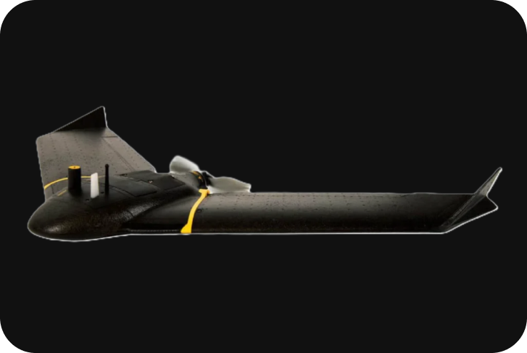
SenseFly eBee X
The SenseFly eBee X is a fixed-wing professional drone designed for aerial mapping, surveying, and data collection across a wide variety of industries. Known for its versatility, long flight endurance, and precision, the eBee X can carry multiple payloads, including high-resolution RGB cameras, multispectral sensors, and thermal cameras. It’s widely used in sectors such as agriculture, land surveying, construction, and environmental monitoring due to its ease of use and advanced features like RTK/PPK for centimeter-level accuracy.
Technical Specifications
1. Key Specifications:
- Drone Type: Fixed-wing drone.
- Max Flight Time: Up to 90 minutes (depending on payload).
- Max Coverage: Up to 500 hectares (1,235 acres) in a single flight at 120m altitude with the Aeria X camera.
- Wingspan: 116 cm (3.8 ft).
- Weight: Starting from 1.6 kg (3.5 lbs) depending on payload.
- Max Takeoff Weight: 1.6 to 2.2 kg (3.5 to 4.9 lbs), depending on payload.
- Cruise Speed: 40-110 km/h (25-68 mph).
- Wind Resistance: Up to 46.8 km/h (12.9 m/s or 29 mph).
- Operating Temperature: -10°C to 40°C (14°F to 104°F).
- GNSS: GPS + GLONASS, and optional Galileo.
- RTK/PPK: Optional Real-Time Kinematic (RTK) and Post-Processed Kinematic (PPK) for centimeter-level accuracy.
2. Endurance and Range:
The eBee X is designed for long-endurance flights, making it an ideal choice for large-area mapping projects where extensive coverage is required.
- Flight Time: Up to 90 minutes, providing longer operational time in the air, reducing the number of flights needed for large areas.
- Max Coverage: Covers up to 500 hectares (1,235 acres) per flight at 120 meters (400 ft) altitude, depending on the payload and mission.
- Takeoff & Landing: The drone can be hand-launched and lands using a belly landing, eliminating the need for runways or additional equipment.
3. Payload and Camera Options:
The eBee X is compatible with multiple payloads, making it versatile for a range of applications, from standard photogrammetry to multispectral imaging and thermal mapping.
- SenseFly Aeria X:
- Type: High-precision RGB camera.
- Resolution: 24 MP.
- Global Shutter: Allows for sharp images without motion blur.
- GSD: Down to 1.6 cm/pixel at 120 meters, ideal for high-resolution mapping.
- SenseFly Duet T:
- Type: Dual thermal and RGB camera system.
- Thermal Resolution: 640 x 512 pixels.
- RGB Camera: 24 MP.
- Ideal for applications like energy audits, search and rescue, and building inspection.
- SenseFly S.O.D.A. 3D:
- Type: Specialized RGB camera.
- Field of View: Captures oblique and nadir imagery for 3D modeling.
- GSD: Down to 1.5 cm/pixel at 100 meters, perfect for 3D reconstruction.
- MicaSense RedEdge-MX:
- Type: Multispectral camera.
- Bands: 5 spectral bands (Blue, Green, Red, Red Edge, Near Infrared).
- Ideal for precision agriculture, environmental monitoring, and crop health analysis.
- MicaSense Altum:
- Type: Advanced multispectral and thermal camera.
- Bands: 5 spectral bands plus thermal.
- Ideal for advanced agricultural monitoring and scientific research.
- Parrot Sequoia+:
- Type: Multispectral sensor.
- Bands: 4 spectral bands and an RGB sensor.
- Suitable for agricultural analysis and plant health assessment.
4. RTK/PPK for High Precision:
The eBee X offers both RTK (Real-Time Kinematic) and PPK (Post-Processed Kinematic) options for centimeter-level accuracy, allowing for highly precise georeferencing without Ground Control Points (GCPs).
- RTK: Real-time corrections for on-the-fly data accuracy.
- PPK: Post-processed kinematic correction for survey-grade accuracy, ideal for environments where RTK might face connectivity issues.
- Accuracy: Can achieve down to 3 cm accuracy horizontally and vertically when using RTK/PPK technology.
5. Flight Performance:
The eBee X offers excellent flight performance, even in challenging environments.
- Wind Resistance: Operates in winds up to 46.8 km/h (12.9 m/s or 29 mph), making it highly resistant to harsh weather conditions.
- Automatic Flight Plan Adjustment: The eBee X can automatically adjust its flight plan based on wind conditions, ensuring consistent coverage and safe flight operations.
- Automatic Geofencing: The system supports geofencing, allowing operators to define a safe flight area, and the drone will automatically return if it approaches the boundaries of the geofence.
6. QBase Mission Planning Software:
The eBee X integrates with QBase 3D, SenseFly’s powerful mission planning and flight control software:
- Flight Planning: Allows users to define mission boundaries, set altitude, and control flight parameters like overlap and sidelap for optimal data collection.
- 3D Flight Planning: Includes terrain-following functionality, ensuring the drone adjusts its altitude based on the terrain to maintain a consistent Ground Sampling Distance (GSD).
- Real-Time Data Visualization: Provides real-time updates on the drone’s status, including altitude, speed, battery levels, and mission progress.
- Automated Data Management: The software organizes and processes data, making it ready for post-processing in photogrammetry software like Pix4D or Agisoft Metashape.
7. Applications:
The eBee X is designed for a wide range of professional applications:
- Land Surveying & Mapping: High-resolution imagery for generating accurate Orth mosaics, digital terrain models (DTMs), and digital surface models (DSMs).
- Agriculture: Multispectral payloads like the RedEdge-MX allow farmers and agronomists to monitor crop health, detect stress, and optimize yields.
- Forestry: Provides precise data on tree counts, canopy analysis, and forest health monitoring.
- Environmental Monitoring: Useful for tracking changes in ecosystems, coastlines, and water bodies, and for conservation efforts.
- Construction and Mining: Tracks progress on construction sites, generates 3D models, and calculates stockpile volumes and cut/fill analyses.
- Energy and Utilities: The Duet T payload (thermal + RGB) enables detailed inspections of solar farms, pipelines, and power lines.
8. Safety and Redundancy Features:
The eBee X is equipped with various safety features that ensure safe and reliable operations.
- Failsafe Mechanisms: The drone will automatically return to its takeoff point if it loses connection with the ground station or experiences low battery levels.
- Obstacle Avoidance: While the eBee X does not have active obstacle avoidance, the flight planning software and autopilot system are designed to avoid obstacles based on pre-mission planning.
- Redundant GNSS: The system uses multiple GNSS (GPS, GLONASS, and optional Galileo) for robust and reliable positioning during flight.
9. Integration and Data Processing:
The eBee X integrates seamlessly with leading photogrammetry and data processing software for various applications:
- Photogrammetry: Compatible with Pix4D, Agisoft Metashape, and DroneDeploy for processing aerial images into high-resolution Orth mosaics, DSMs, and 3D models.
- Multispectral Analysis: Data from the RedEdge-MX and Altum payloads can be processed in software like Pix4Dfields and QGIS for agricultural analysis, crop health monitoring, and vegetation management.
10. Battery System:
The eBee X uses a modular, hot-swappable battery system.
- Battery Life: Each battery provides up to 90 minutes of flight time, depending on payload and weather conditions.
- Battery Management: The drone’s software provides detailed information on battery health and status, ensuring safe and efficient battery usage during missions.