
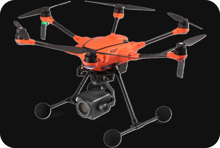
Yuneec H520 RTK
The Yuneec H520 RTK is a professional-grade hexacopter drone designed specifically for surveying, mapping, industrial inspections, public safety, and 3D modeling. Known for its precise positioning and high accuracy, the H520 RTK stands out due to its Real-Time Kinematic (RTK) module, offering centimeter-level positioning accuracy. It is particularly well-suited for geospatial applications requiring precise data, such as photogrammetry, construction site mapping, and infrastructure inspections.
Technical Specifications
1. Key Specifications:
- Drone Type: Hexacopter (6-rotor UAV).
- Max Flight Time: Up to 28 minutes (depending on payload and flight conditions).
- Max Transmission Range: Up to 7 km (with the ST16S ground station controller).
- Payload Capacity: Supports a variety of interchangeable cameras and sensors.
- GNSS System: Built-in RTK (Real-Time Kinematic) module for centimeter-level accuracy.
- Battery: LiPo 4S 5250mAh, offering reliable power for extended missions.
- Max Speed: Up to 17 m/s (approx. 61 km/h).
- Operating Temperature: 0°C to 40°C (32°F to 104°F).
- Wind Resistance: Stable in winds up to 45 km/h (28 mph).
2. RTK Module for High-Precision Accuracy:
The RTK system integrated into the H520 RTK drone enables real-time, centimeter-level positioning accuracy. This feature makes it ideal for mapping and surveying tasks that require exact spatial measurements without the need for ground control points (GCPs). The RTK module uses GPS, GLONASS, Galileo, and BeiDou satellite systems to achieve its high level of precision.
- Centimeter-Level Accuracy: With RTK corrections, the H520 RTK offers centimeter-level accuracy, which is essential for creating accurate 3D models, Orth mosaics, and detailed maps.
- PPK Compatibility: In addition to RTK, Post-Processed Kinematic (PPK) functionality is also supported for enhanced post-flight data accuracy in areas with poor GNSS signals.
3. Design and Build:
The Yuneec H520 RTK features a hexacopter design, offering greater stability, especially during windy conditions or in complex environments where precision flight is required. Its six-rotor system ensures redundancy and reliability—if one motor fails, the drone can still safely fly and complete its mission.
- Hexacopter Configuration: The six-rotor design provides enhanced flight stability and redundancy in case of motor failure.
- Foldable Design: The drone is compact and foldable, making it easy to transport and deploy on-site.
- Bright Orange Color: The H520 RTK’s high-visibility orange color makes it easy to spot in the sky, enhancing safety, especially during complex industrial or rescue missions.
4. Payload and Camera Options:
The Yuneec H520 RTK supports a range of interchangeable cameras, allowing users to select the appropriate sensor for different applications such as aerial photography, inspection, or surveying.
-
E90 Camera
- 20 MP 1-inch CMOS sensor.
- Capable of shooting 4K UHD video at 60 fps.
- Suitable for high-resolution aerial imagery, mapping, and 3D modeling.
- Wide 91° field of view for capturing large areas with fewer passes.
-
E30Z Camera
- 30x optical zoom camera.
- Ideal for infrastructure inspection, public safety, and search and rescue operations.
-
E10T Thermal Camera
- Dual-sensor camera combining thermal imaging and RGB in one unit.
- Available with 320×256 or 640×512 thermal resolution options.
- Ideal for search and rescue, firefighting, solar farm inspections, and electrical utility inspections.
5. Flight Performance:
The Yuneec H520 RTK is designed for professional use in various industrial and commercial applications, offering reliable performance across a range of environmental conditions.
- Max Flight Time: Up to 28 minutes with the E90 camera, although the exact flight time varies based on payload and wind conditions.
- Max Transmission Range: The drone can be controlled up to 7 km away using the ST16S Ground Station, which also provides real-time video feed and telemetry data.
- Stable Flight: The drone is equipped with advanced stabilization systems that ensure stable hover and precise flight in challenging conditions, such as strong winds or dense urban environments.
6. Applications:
The H520 RTK is a versatile drone used in many industries that require high-precision mapping, inspection, and data collection.
-
Surveying and Mapping:
- High-Precision Mapping: The RTK system allows for highly accurate surveying, topographic mapping, and Orth mosaic generation, even in large or complex areas.
- 3D Modeling: The E90 camera captures high-resolution images for creating 3D models and point clouds used in construction, mining, and land development.
- Efficient Workflow: The RTK eliminates the need for ground control points (GCPs), significantly reducing setup time and improving workflow efficiency.
-
Construction:
- Site Monitoring: Provides detailed aerial data for site planning, construction progress tracking, and volumetric measurements.
- Stockpile Measurement: The drone’s precise mapping capabilities are ideal for stockpile volume calculation on construction and mining sites.
-
Infrastructure Inspection
-
- Power Line Inspection: With the E30Z camera and RTK system, the H520 RTK can inspect power lines, wind turbines, and other critical infrastructure safely from a distance.
- Thermal Imaging: The E10T thermal camera can detect heat anomalies in electrical systems, making it valuable for inspections of solar farms and substations.
-
Public Safety
- Search and Rescue: The thermal imaging capabilities of the E10T camera make the H520 RTK a vital tool for locating missing persons or survivors in difficult-to-access areas or poor visibility conditions.
- Firefighting: The thermal camera can help detect hot spots in fire situations, enabling firefighting teams to make more informed decisions.
-
Agriculture
-
- Precision Agriculture: The H520 RTK can be equipped with multispectral sensors for monitoring crop health, analyzing vegetation with NDVI indices, and optimizing irrigation and fertilization practices.
7. Software and Mission Planning:
Yuneec provides a comprehensive ecosystem of mission planning and flight control software tools designed for professional use.
- DataPilot Software: The Yuneec DataPilot software allows for fully automated mission planning. Users can create complex flight missions using waypoints, area mapping, survey grids, and linear inspections. It’s optimized for georeferencing and is compatible with industry-standard mapping software like Pix4D, DroneDeploy, and Agisoft.
- ST16S Ground Station: The ST16S is an all-in-one ground station controller with a 7-inch HD screen that provides live video and telemetry. The controller allows for real-time mission adjustments and supports dual-pilot operations (one for piloting and another for camera control).
8. Safety and Redundancy:
The H520 RTK is built with a strong focus on safety and redundancy to ensure reliability in professional environments.
- Hexacopter Design: In case of motor failure, the hexacopter design ensures that the drone can still fly and land safely with the remaining five rotors.
- Failsafe Systems: The drone is equipped with multiple failsafe features, including Return-to-Home (RTH), low battery warning, and GPS signal loss handling.
- Obstacle Avoidance: The H520 RTK features a collision avoidance system (with front-facing sonar), helping to navigate complex environments and avoid obstacles during flight.
9. Battery System:
The H520 RTK uses high-capacity LiPo 4S batteries that offer up to 28 minutes of flight time, depending on the payload. The battery management system monitors the charge status and provides real-time alerts to ensure safe flight operations. Additional batteries are easily swappable, minimizing downtime between missions.